First of all I’d like to thank Tracy for all the detail and commentary. She tracked me pretty well and nailed about 95% of my locations for camping. She is amazing and I couldn’t have done this without her support!
After being calorie deficient, strengthened from climbing 2500 feet per day on average, and accustomed to carrying 40lbs on my back; I was able to knock off a lot of miles/day in the later days of the trip and got way ahead of schedule.
Yesterday afternoon and evening, I ate 4lbs of chicken and French fries and polished off a lot of beers with many of the people I met along the trail. After getting up a 1:45am that night (Tracy nailed the time) I was dead tired and fell asleep in the Whitney Portal campground at 8pm. This morning entailed finishing my book (for the 2nd time), cleaning out my backpack of worthless items, and eating a 2lb breakfast plus a pot of coffee :).
I packed up around 10am with my very creative sign with the words “Lone Pine” on it, and started walking down the road from the Whitney portal to the “single tree” town. Luck would have it that the 2nd vehicle that passed was a pick-up loaded with a family from Reno that offered for me to jump in. They drove me 11 miles (and 2,000 feet of descent) to the Lone Pine Best Western. I must have good karma since the motel even had a clean room ready for me at 11am. Also, they had the package of clean clothes I shipped them.
After a shower and an additional bath, I unpacked, repacked, and headed into town to the drug store for needed items such as band aids, lip balm, and hand lotion to patch all my minor wounds. I spoke with Eddie and Chris, who were delayed by weather, so I did the logical thing and planted my butt on a stool in Jake’s Saloon to watch football and drink beer until they made it to town.
Back at the hotel now so I will end this, but expect a, as Tracy says, “studio quality” video by the end of next week with my adventures.
He made it. Jim called at 6 am local time Friday morning from the summit of Mt. Whitney, at 14,500 feet, where he was hanging out waiting for the sun to rise. I forgot to ask what time he had started, but the trip entailed another 3,000 feet of climbing in the six-mile stretch from Guitar Lake to the top, so unless he strung up a duct-tape pulley system, he must have been packed up and on the trail sometime between midnight and 2 am.
I talked to him again about six hours later, and he had made it all the way down to Whitney Portal—that’s another ten miles with 6,000 feet of descent, punctuated by the notorious “99 switchbacks.” At that point, Jim was already wearing his flip flops and carrying nothing but a beer, and he sounded awesome. His plan for the rest of the day was to eat and drink like he was going to the electric chair, and then to camp tonight at Whitney Portal. Tomorrow he’ll hitch a ride into Lone Pine (the nearest town) where Eddie and our friend Chris will be meeting him, ready to do some serious hiking I’m sure. They’ll spend Saturday night in Lone Pine, and then head to the airport on Sunday.
I’m going to hand over the reins now and let Jim take it from here; he can fill in the details, correct all of those guesses I made, and show you guys some actual pictures he took along those 222 miles of trail. Thanks for indulging my “guesting” in the meantime. Congratulations and here’s to Jim. Amazing. YOU DID IT.
Hello from Baltimore. It’s almost as pretty here as it is in Kings Canyon or Sequoia National Park, so I’m guessing Jim might be a little jealous right now, which may account for his apparent hurry to get out of there. Rosie Ruiz Skelding continues to fly along the trail, and on Tuesday (Day 14), he made it from 60 Lakes Basin. up and over Glen Pass, at 11,978 feet, and even though the highest pass is still to come, Glen Pass is the steepest and is reputed to be the most difficult. It is also supposed to have some of the most spectacular views on the trail. After climbing up and over Glen Pass, Jim would head down through Vidette Meadow and Bubbs Creek (with a view of Junction Peak) and back up to around 10,500 feet to camp at Center Basin Trail for his last night in Kings Canyon.
On Wednesday Jim continued his climb up to Forester Pass, which is the highest pass on the John Muir Trail, at ~13,200 feet, and which marks the entry into the final section of the trail: Sequoia National Park. Adding further insult to the nearly 3,000-foot climb in three-and-a-half miles is the steep, rocky trail going back down. The south side of Forester Pass comprises a series of switchbacks cut into the rock that makes for a somewhat tricky descent, but that features some really beautiful views along the way. Tyndall Creek is at treeline, followed by Tawny Point, which has a panoramic view of the Great Western Divide (the range that blocks the view of Mt. Whitney from the west side of Sequoia). Just past Tawny Point is Bighorn Plateau, where Jim probably got his first good view of Mt. Whitney. Two big creek-crossings follow—Wright Creek and then Wallace Creek—and Jim set up camp near Wallace Creek on Wednesday evening, at the High Sierra Trail Junction, with more than 196 miles behind him.
It looks as though he got an early start out of the Wallace Creek campground on Thursday morning, but then SPOT went quiet for most of the day. For many miles through Kings Canyon and Sequoia, the John Muir Trail and Pacific Crest Trail are one and the same, but at this point, the trails diverge, and JMT hikers make a hard left turn towards Mt. Whitney, while PCT hikers continue southbound (good idea for next trip: Canada to Mexico on the PCT?). Eddie and I were speculating that Jim might just head all the way up to the summit of Mt. Whitney today rather than stopping to camp at Guitar Lake, but at this point, he was already a day ahead of schedule, so a summit today would have made it two. Plus, it’s always nice to do an “alpine start” (except for the pitch-dark and freezing-cold parts), and get to the summit at sunrise. So it turned out to be a “short” mileage day, with Jim’s setting up camp at Guitar Lake early in the afternoon. Below is a view of Mt. Whitney from Timberline Lake, which is on the way to Guitar Lake. The JMT traverses that entire ridge to reach the summit.
So, according to SPOT, Jim got to Guitar Lake around noon local time, and just hung out there for the rest of the day. Guitar Lake is the most popular “way station” on the approach to Mt. Whitney, and the last good place to restock with water, so I’m guessing there were lots of other skinny, bearded, less-than-fresh-smelling people with twice their normal allotments of red-blood-cells camping alongside him and getting ready to wake up in the wee hours to start their summit bids. Whitney ahoy.
After nearly three days of SPOT radio silence with no tracking signals, Jim appeared on Sunday afternoon at Mile 157—all the way down near Marjorie Lake. Official investigators from the International Through-Hiking Federation were reported to be in the area asking questions, and confidential sources say they are referring to Jim as “The Rosie Ruiz of the John Muir Trail,” and currently working to rule out quantum mechanics, teleporting, and a zip-line rigged from duct tape as possible alternative modes of transport, any of which could garner him a 211-race suspension.
Seriously, though, right now (Monday night, Day 13), Jim is already at 60 Lakes Basin, which is more than 173 miles down the trail, at the campground at which he had originally planned to camp on Day 14—before the Happy Isles pass came through and put Jim and Eddie a day behind schedule—so not only has he made up an entire day, but he has also gained another one.
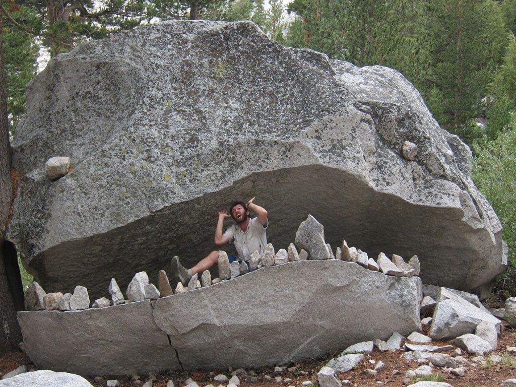
The trail from Evolution Lake to Le Conte Canyon goes for eight miles above tree line, and Jim would have camped up there on Friday night, near Sapphire Lake, where the trail is wide open and the views look amazing. Jim will have to relay the details when he gets back, but I’m guessing, subject to some alternative-transport theory, that he did not hang around to camp for two nights at Sapphire Lake, and instead high-tailed it out of there on Saturday and made it all the way to Deer Meadow–or perhaps even another seven miles past Wanda Lake at 11,400 feet, and then up to Muir Pass at almost 12,000 feet. Muir Pass is a really long climb in any case, but the last mile is supposed to be pretty wretched–with lots of big, loose gravel. At the top of is the landmark Muir Hut, which was built in the 1930s as a tribute to John Muir and as a shelter for hikers. Helen Lake would be next, followed by the “unnamed lakes” which it seems is actually their name (the Muir Hut link above has lots of good pictures of those lakes as well), then past the Black Giant (a peak), and on through Le Conte Canyon, crossing Big Pete Meadow and Little Pete Meadow, respectively, along the way. There is this enormous and really cool rock formation (called in the alternative, “Monster Rock,” “Whale Rock,” and the “John Muir Rock Creature,” which sits on the trail near Big Pete Meadow. That embedded link above is to the only picture I could find that did not include a person sitting or lying in the rock mouth. Most of them look like this, and they never fail to crack me up:It does provide a better appreciation of how big the thing is, though. After the two “Petes” would come Grouse Meadow, and then the trail turns left (east) along Palisade Creek and starts to climb again for another ten miles, all the way up to Mather Pass at 12,100 feet (the highest elevation on the trail so far). The Deer Meadow campground is along that stretch before the pass, at about mile 142; but as I mentioned above, another possible scenario is that Jim skipped the Deer Meadow campground, just continued over Mather Pass on Saturday, and camped at around mile 150 (just south of and on the way down from Mather Pass) that night.
When SPOT started to send signals again on Sunday afternoon, Jim was already down near Lake Marjorie and Pinchot Pass, which meant that sometime between Saturday and Sunday, he had climbed the Golden Staircase and gone up and over Mather Pass (likely Saturday) and then down a series of switchbacks into Upper Basin, after which the trail starts to climb again all the way up and over Pinchot Pass—at 12,130 feet. Pinchot Pass was the “new” highest point on the trip so far, and is the second-highest pass of the eight on the John Muir Trail.
It looks as though Jim camped on Sunday night just south of Pinchot Pass, and then hiked about 16 tough but gorgeous trail miles on Monday—starting with a descent of 3,700 feet from the pass down to Woods Creek, and then across the fancy Woods Creek single-track suspension bridge and into the Rae Lakes area, in which he would set up camp for the night at 60 Lakes Basin Junction. I found a link that gives a pretty good “photo tour” from Sapphire Lake all the way through this point (and farther)—just click on the right arrow in the frame itself and scroll through the series. Spoiler alert: Click here to learn how Jim got down there so quickly.
I should really call this a “guessed” post because either Jim’s phone is out of power or there is no cell-phone reception, or both, actually, since he forgot to turn off his phone for a full day early in the trip, and didn’t bring his solar charger; so I’m using a combination of SPOT signals, Google Earth pictures, JMT websites, and Jim’s original trip plan to piece together a rough play-by-play.
Now that I’ve got my remote bearings (and learned how to count), it looks as though Jim restocked at Muir Trail Ranch on Wednesday afternoon when he arrived (which was Day 8 and not Day 9, by the way—so I just fixed the earlier post), and then kept going into the next section of the trail. This section, which runs through Kings Canyon National Park for the next 75 miles, is supposed to be one of the most spectacular, but also one of the toughest, weaving among several 14,000-foot mountains, and featuring five of the eight total passes on the JMT—the last of which, as the trail crosses into Sequoia National Park, is the highest of all of of them, at 13,180 feet.
Anyway, after stocking up and leaving the Muir Trail Ranch area, Jim crossed into Kings Canyon, where Paiute Creek meets the San Joaquin River and the trail then runs parallel to the river for several miles, with lots of bridges and at least one actual creek crossing. Jim set up camp at Aspen Creek on Wednesday night (about 5 miles into the Kings-Canyon section), and then packed out Thursday morning, which took him across the Goddard Canyon Trail, and into Evolution Valley—through a nice, relatively flat, and really beautiful section across Evolution Creek. This is the creek crossing with no bridge, but even when the water is “high” it’s only at about knee-level; and the trail then winds through Evolution Meadow (I found a nice picture here). SPOT did not send a signal on Thursday until 2:40 pm California time, and Jim had already made it to the eastern end of McClure Meadow, where he would be camping for the night. According to SPOT, he did some hiking and exploring around the area, which has incredible scenery and mountain views. Here is a link to a picture of McClure Meadow, which has a link to some other photos as well. That mountain in the distance is the Hermit, which is part of the Evolution Range.
So now I have to extrapolate, or interpolate, or speculate, but Friday’s destination was Sapphire Lake. Jim was planning to take a rest day here and camp for two nights (and by “rest,” he means taking a day-trip on Saturday to climb one of the mountains near by—made “restful” by his not having to carry a full pack). My guess is that he may still do that, even though he’s a day behind his original schedule, because he has enough food for the rest day and is making great progress. The trip from McClure Meadow to Sapphire Lake climbs up to Evolution Basin, which has a series of 13,000-foot mountains named, as one may surmise, after scientists such Darwin and Mendel. The Kansas legislature is working on a bill to have the area renamed “Creation Basin.”
Once I see a SPOT reboot, I’ll post a more detailed update.
Hi all, Tracy again. Work is crazy this week, and has been keeping me away from the website, so I am sorry for the delay in posting this update. Everything sounds like it’s going pretty perfectly, and Jim is blazing along the trail and feeling really good. SPOT (a/k/a “Eddie”) is acting up again, but you can still get a good idea of where Jim has been, except that all of the tracking points from the first three days are gone, and the tracker started over again at number 1 in a place that’s not even close to the trail. Since then, though, SPOT has seemed to pick up the correct location (#2 through #49 spots as of this posting) and has stayed generally on track from there with some intervals of radio silence that appear as straight lines on the map. Note that the numerical coordinates that are shown with each spot entry are all coming up the same, so just be sure to avoid using the coordinates themselves if you’re trying to see the trail or look at photos via Google Earth or another satellite or mapping application.
Donohue Pass (over which Jim climbed on Friday) marks the end of Yosemite National Park section of the trail, and forms the northern border of the Ansel Adams Wilderness section. On Saturday Jim went from Island Pass to Red’s Meadow and Devil’s Postpile, in the Inyo National Forest. Devil’s Postpile is a group of very cool looking basalt columns that were formed from cooling magma (to be said in a Dr. Evil voice). Jim made quick work of that section of the trail, and moved into the John Muir Wilderness Section, which starts near Mt. Ritter and Banner Peak and features the Red Cones, which are also lava formations but would be a good name for a band. On Sunday, Jim went from Red’s Meadow past Deer Creek and over Duck Pass, passing a series of really pretty lakes along the way, including Duck Lake and Purple Lake, all with great views of the eastern Sierras, and he then camped near Virginia Lake. I think this day was originally planned to end at the campground at Duck Creek Crossing, but Jim blew by that spot and continues to make up time.
I found some photos of Duck Pass, Purple Lake, Virginia Lake, and other views from that section of the trail here.
Monday’s leg started near Virgina Lake and went up and over Silver Pass (10,900′), down to Silver Pass Lake (around the JMT 80-mile mark), through the Vermillion Cliffs, to Lake Edison. I might be getting my combinations mixed up a bit, but I think this is about right. Lake Edison is a popular place to stop and camp—hikers can take a ferry to the Vermillion Valley Resort (where one might have wanted to take a badly needed shower, for example), and there is a supply-drop station there as well—so through-hikers can ship food and supplies before they leave home, and then pick them up and restock during their trips. However, Jim packed in eight-days’ worth of food at the start, so he did not have to orchestrate a supply shipment to Vermillion Valley. He’s got one coming up at another station that is farther south.
I talked to Jim on Tuesday, mid morning California time–he sounded great. He said the weather had been really nice, and that the morning was cold, so he got up extra early and was on track to do well over 20 miles and get to Marie Lake to camp for the night. That kind of distance is especially impressive given that the hike out of Lake Edison entails a long, steep climb with lots of switchbacks to get up and over the ridge, after which the trail drops down to Bear Creek, and goes across Rosemarie Meadow and hits Marie Lake on the way to Selden Pass. Jim also told me he was getting really skinny, but eating like crazy, and that he still had two days’ worth of food left (perfectly planned, of course). The big shock is going to come when he reloads that bear canister with another 8-to-10 days’ worth of food, and then has to carry it with his smaller sinewy body. He is going to be so well trained for the Mogollon race, though, I am unabashedly jealous of the whole thing, but also really excited for him.
Today (or yesterday really), was the climb up and over Selden Pass (10,900′) to Heart Lake—which is a big deal because this is the halfway point of the trail—about the 105 mile-mark. The trail then winds around Sally Keyes Lake, still at over 10,000 feet, and then down to the Muir Trail Ranch. This is an even bigger deal because Muir Trail Ranch is the place where Jim shipped his next load of food and supplies, so he will restock at the ranch tomorrow, and I’m hoping he has a chance to take a little break and check out the natural hot springs near the ranch.
That’s the download. I’d make it shorter if I had more time, but I will try to be better about keeping everyone updated. Congratulations to Jim for hitting the HALFWAY milestone.
Hi, it’s Tracy again. I got back to Austin Sunday night and have been delinquent in finishing this post to relay the news from Jim and Eddie. On Thursday, after Eddie made what seemed to be an excellent recovery from a brutal first day on the trail, he had another bout of altitude sickness followed by a sleepless night (he told me he spent 9 hours lying in his tent with his eyes open). Things got worse on Friday morning when they set out on the trail and Eddie had a pain in his chest as they climbed. For those of you who don’t know Eddie, he has an aortic aneurysm that was diagnosed several years ago. He has been under the care of two of the top aortic specialists in the US (he keeps them on each coast—one at Cornell and the other at Stanford), and has continued to run ultras, hike 14ers, and generally behave like a mountain-goat, with strict adherence to few hard-and-fast rules set by these doctors. They include such things as keeping his heart rate and blood pressure below certain levels, and slowing down or stopping the minute he experiences chest pain.
Eddie has always been a Teflon man with an iron constitution and [insert choice of additional “indestructible”-type metaphor here], but his survival of a rattlesnake bite a couple of years ago inflated those perceptions even further: Eddie was out in Briones (or nearby east-bay trails) on a run by himself, when he felt what he thought was a stick snapping against his leg as he stepped on it—but then when he looked down, he saw the fang punctures. He walked calmly all the way back to his car–I want to say it was three miles—and then drove himself to the hospital, where he spent several days in intensive care and required 49 vials of antivenin (seven-times the volume “normally” needed for treatment). First, they thought he would die, then they thought he would lose his leg, then they thought that even if were able to keep his leg he might not be able to walk again…and then he ended up with a not-so-bad scar. I digress, but that’s the gist of the resilience thing with Eddie. His friends tend to take for granted that he can do anything (as we try to keep up), and forget that he has a real heart condition to which we need to pay attention.
So anyway, back on the trail, the guys slowed their pace and Eddie’s chest pain subsided, but then along came another pain, and this time it was during a downhill segment when he was maintaining a lower heart-rate. So he blew the whistle, threw the flag, and gave himself a red card. Jim got him packed up and on his way back to the ranger station at Tuolumne Meadows. Then, after many many hours and a series of rides on shuttle buses, Amtrak and BART trains, and a taxi (all of which by Eddie’s own account had to undergo intensive fumigation treatments after his rides), he made it back to Walnut Creek late on Friday night. Eddie is fine and all is well. He is planning to head down south this week or next, and will meet Jim at Lone Pine (the closet town to Whitney Portal) at the end of the month when, if all goes roughly as planned, Jim will emerge from the wilderness.
Meanwhile, Jim is now armed with the SPOT, which he has renamed “Eddie” and to which he now talks to keep him company. He started out on his solo tour on Friday and made it through Lyell Canyon and over Donohue Pass, and camped Friday night near Island Pass and Banner Peak. Google Earth has some good photos of the area linked to the satellite map (I took the SPOT coordinates and dropped them in). Here’s another one. Of course there is no snow right now, but these pictures are a nice placeholder while we wait for the real ones. Speaking of SPOT, it is still being spotty, so don’t worry if it looks on the map as though nothing is happening out there (e.g, Saturday). Jim is making great progress and all is well. This entry is already too long, but I will post a catch-up tomorrow with highlights from the past couple of days.
Congratulations to Eddie for making it through a rough but beautiful abbreviated trip, and cheers to a second early retirement by the original Man of Leisure.
Hi all. This is Tracy, with a detailed debrief from Day One (and a short update from Day Two as well). Jim, Eddie, and I got on the road to Yosemite Wednesday morning at 6 a.m., after a visit to the new Starbucks in Oakhurst for the guys’ last good cup of coffee for the rest of the month. With freshly minted Happy Isles permit in hand, we wended our way into the park to the actual “no-asterisk” start of the John Muir Trail (elevation 4,040′), found a parking lot that was about a half-mile from the trailhead, and were packed up and on the trail by 8:00 a.m. Well, the guys were packed up, that is—to the tune of about 45 pounds apiece—I had a water bottle. Note the mileage to Mt. Whitney:
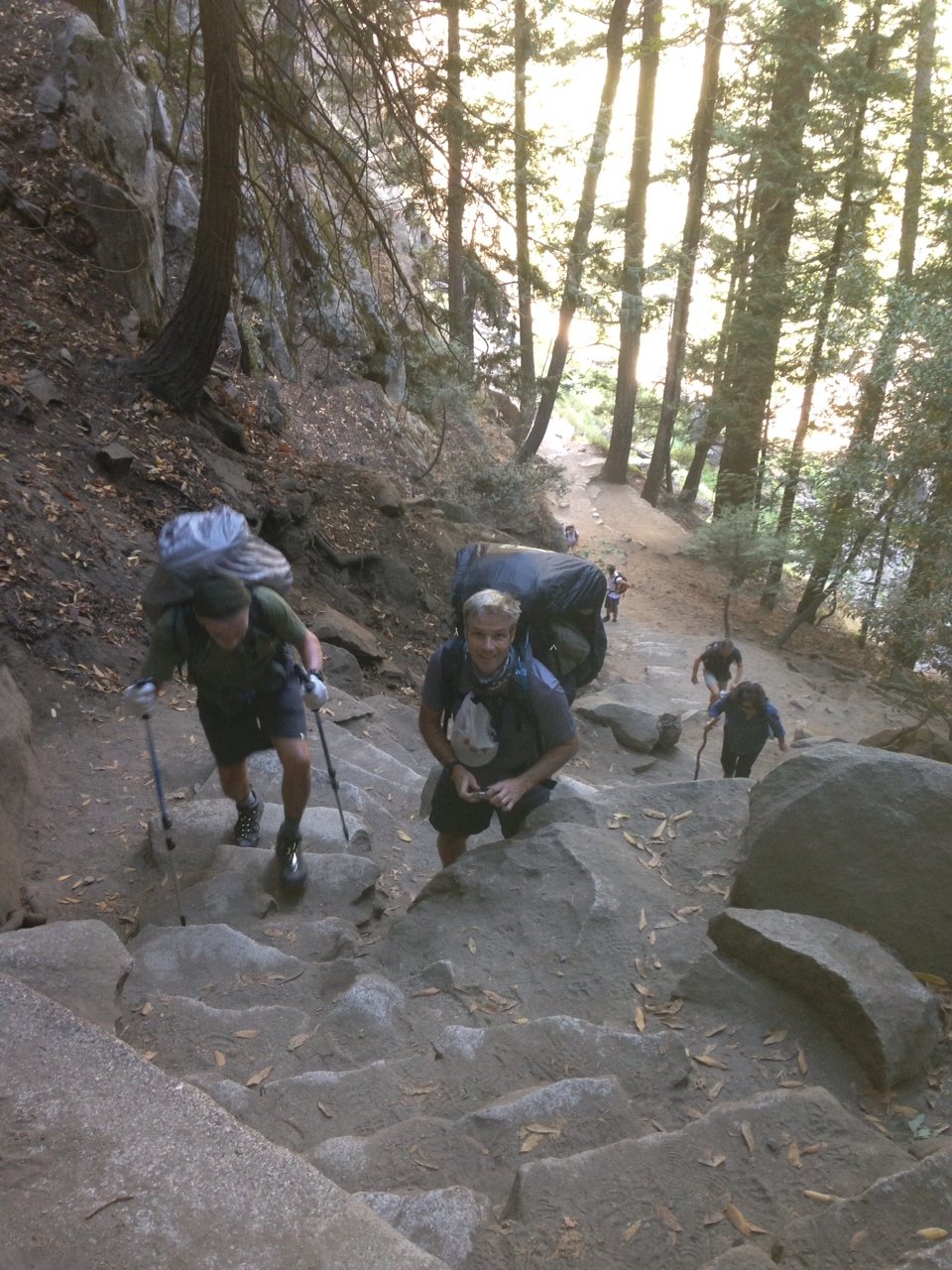
The morning was pretty cold, which was a nice way to start, although I’m not sure Eddie would attest to the chill’s being a fair counterbalance to the insulting barrage of steep stone steps and 1,000 feet of climbing in the first mile. We took the Mist Trail to Vernal Falls, which usually means a good soaking on the way up the steps, so the guys stopped at the first bridge to put on their pack covers. This led to lots of rummaging around and poles flying, followed by a nearly complete unpacking of Eddie’s backpack and a discovery of items he did not know he was carrying, such as a giant syringe (part of a snake bite kit?), a bale of nylon twine (two different gauges), and some gaiters that were way too big for his skinny legs. (I now have these items in my possession in San Francisco, and have had a few offers for the syringe.) As it turned out, the pack covers were unnecessary since the falls were not falling very hard, but it was a worthwhile exercise since it relieved Eddie of some pack weight.
We continued to climb—first to Vernal Falls,
and then up and over the south slope of Mt. Broderick (~6,700’) and Liberty Cap (~7,100) on the trail to Nevada Falls (~6,000′).
As you can see, it was a bit unrelenting on the way up, but it was really beautiful.
(These photos are from my iPhone and don’t quite do justice to the scenery, but Jim already has lots of great pictures on his camera, and he will post a link to them when he gets back, after which the man-of-leisure will commence to making what is sure to be a studio-quality video production.)
OK, so remember that sign on the valley floor at the start of the trail that said it was 211 miles to Mt. Whitney? Well, here is the sign at the top of Nevada Falls (yes, we were going the right way):
On a side note, this was also the first point at which Eddie’s SPOT actually sent out a signal, even though he had set it to transmit as soon as we started the hike, so do not worry if you don’t receive regular check-ins from SPOT. There is sporadic cell-phone coverage at certain points along the trail, so I will post updates as I get them.
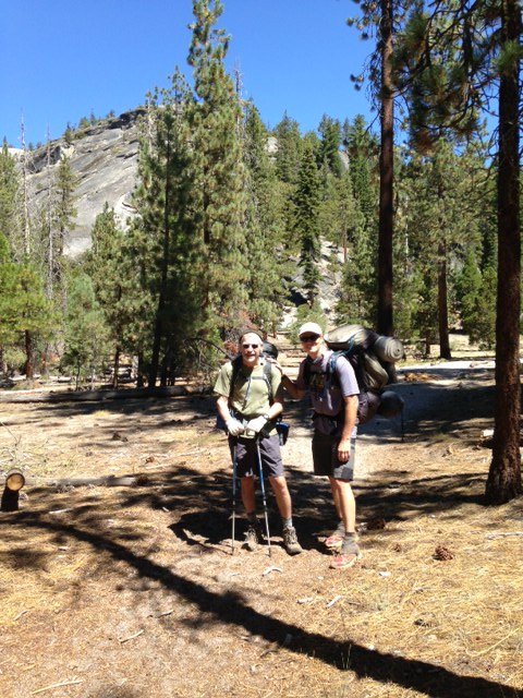
By the time we got to the top of the Nevada Falls, it was pretty hot out, but the trail eased up for the next mile or so as we headed towards Little Yosemite Valley (my turnaround point)–it was sandy and relatively flat, and there were lots of trees and good shade. We took a break there, and Jim MacGyvered my jacket into a backpack, and we loaded up the trash (i.e., Honey Stinger and PR Bar wrappers) along with Eddie’s badminton set and snowshoes, and I turned around to head back down. Their farewell photo is below. Jim and Eddie would then head over that hill behind them and to the right (northeast towards Tuolumne Meadows), and were planning to make their way to Sunrise High Sierra Camp to spend the night.
I turned around here and took the longer route down from Nevada Falls to avoid all of those steps, and as I got to Vernal Falls, with the heat blasting and the tourists streaming in, I found myself wishing I were still up there hiking in the other direction with Jim and Eddie. I made it down pretty quickly, though, so I was in the van and on the park-road by 1:45 p.m. Jim called at about 5:15 to say that Eddie was pretty drained after the long climb, compounded by the altitude and almost no sleep the night before, so they had decided to end the day early and set up camp (maybe at Sunrise Lake?), and then would try for an early start to make up some ground the next morning. In the meantime, I arrived at Eddie’s place in Walnut Creek before 6 pm, dropped off the green monster, showered, re-packed, and headed into the city. Day One was pretty successful all around.
JMT DAY TWO—AUGUST 15, 2013
I spoke with Jim late this afternoon. Eddie had made a great recovery from what sounded as though it was a pretty awful first night at altitude, featuring everyone’s favorite affliction: nausea and vomiting. Jim said everything started to get better after they ate some “real” food for dinner and then again for breakfast. Then, before they hit the trail this morning, Jim transferred some of the heavier gear out of Eddie’s pack (including his bear canister and tent). They were able to start up again at a decent pace, but decided not to push too hard, so they made it a short day and set up camp when they got to Tuolumne Meadows. They are a day behind schedule but have a long time to catch up, and both Jim and Eddie seem to be in good spirits–further buoyed by soft-serve ice cream from the store near the campsite–I could hear Eddie cracking up in the background. Nice recovery and good outlook on Day Two.
Eddie, Tracy, and I made it to Oakhurst at about midnight on Monday night. It was a long drive, but we got here without any trouble. We slept great, had breakfast at the hotel, and headed to the park around 10am to pick up our permit at Wawona. The “official” start of the John Muir Trail is Happy Isles, but after trying every day nearly six months ago—faxing and re-faxing our application for the wilderness permit required for all overnight stays in the park—I managed only to get us a permit to start our hike at Lyell Canyon, which is 33 miles from the start—near Tuolumne Meadows. However, in an interesting twist, the ranger told us this morning that the walk-in permits had just been released, and that the ranger at the Happy Isles station had 2 spots open. This is ultimately good news, since it eliminates that potential “asterisk” from our final report (assuming we make it to the end). The tough part is that it adds at least a full day to the trip, which translates into making sure we have another day’s worth of food (which has to fit into a bear canister), not to mention that it also presents us with an additional 7,000 feet of climbing and 50k of trail. But as Eddie said when the ranger made us our offer we couldn’t refuse, “How could we say no? We came here to hike the JMT and the ranger just gave us more JMT.” I have pasted a link to the entire trail below–we are now starting at the red dot at Happy Isles, instead of the black dot at Tuolumne Meadows. We will still plan to stick to our original schedule, but will arrive a day late to Muir Ranch and will give up our “free” day.
Tomorrow morning we will head out at 5:30 a.m. Tracy will hike in with us to Nevada Falls to “drop us off,” then she will head back out, take Eddie’s van to Walnut Creek, and spend the rest of the week in San Francisco. She will add a guest post here and there as she hears from us, but this will be my last entry until Labor Day weekend, when we hope to emerge victorious and with lots of great pictures. Check the SPOT link above for our coordinates over the next couple of weeks, with the caveat that Eddie’s satellite tracking device was misbehaving today, so don’t worry if it looks as though we haven’t checked in or made progress–in fact, Eddie is on the phone with SPOT right now giving them the business. Have a great rest-of-August. Off we go.
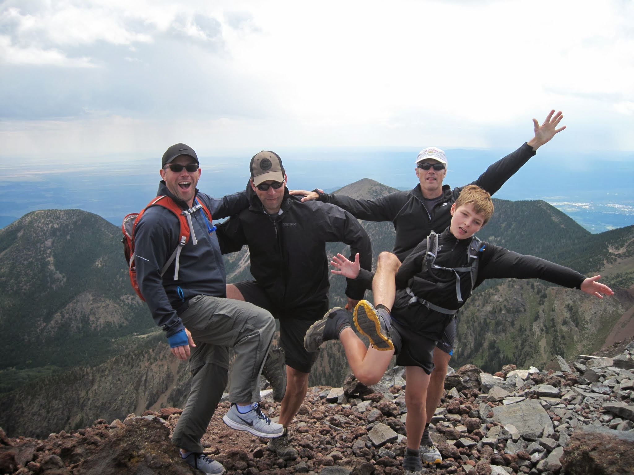
Jason, Nick, Preston, and I met in Flagstaff on Friday night with the intention to climb Mt. Humphreys on Saturday. To help with the acclimatization, late in the afternoon we met at 9,300 ft at the SnowBowl ski resort and played a bit of Frisbee. This accomplished the task of climb high and sleep low. We stayed at the Springhill Suites which turned out to be brand new, modern, and really nice. After a trip to the grocery store for some climbing snacks plus a little vodka and lemonade, we walked across the street for a 5 star dinning experience at Red Lobster. The meal turned out to be fantastic.
We set the alarms for 7am so we could get a meal in before starting the climb. There is a new Mike and Rhonda’s near campus that still has the “hungry man special” which Jason had to try. After the short drive, we were on the trail by 9am. The climb was uneventful and we summited in just over 3 hours. I can’t figure out how to make the Strava widget work (if anyone knows how to make it work in Word Press – shoot me an email at jim@skelmo.com) but I pasted the screen shot below. Lots of pictures at this link https://plus.google.com/photos/100459942408114210497/albums/5910660409688791505 We tried to summit the other mountain, but the trail was closed so we just played on the saddle for a while. We stopped off for a pitcher of beer and a couple of sandwiches at Crystal Creek. Jason remarked that the Grand Rapids is the best sub he’s ever had.
After cleaning up and chilling, dinner was at a restaurant called Café Ole. We met my college advisor and her husband there, Kathy and John Eastwood. The meal, conversation, and company were wonderful. Jason wanted a night cap so we had another pitcher at Granny’s Closet. This morning we drove back to Phoenix via Oak Creek and Sedona. Oak Creek is still as nice as always, but Sedona is a metropolis with what seemed like 10 roundabouts.
Note, some of the pics are from Friday morning when Preston and I were exploring the trails around Pine.
Tomorrow, Tracy and I head off to Oakland where we will meet Eddie O’Rourke (Tracy’s long-time trail-running bud and my JMT co-adventurer) for the start of the John Muir trail. I’m not sure if I will be able to update this while on the road, but you can find Eddie and me via Eddie’s SPOT (satellite transmitter) at: http://share.findmespot.com/shared/faces/viewspots.jsp?glId=0R7Kj7qCKvbOECEdmcOx8HVfxYiT6no3v


